

FARA Regional Survey Project (FARSUP)
Project Description
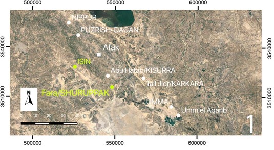
Within the framework of the FARSUP-project (Fara Regional Survey Project), the region between Fara - the Ancient Šuruppak - and Ishan Bahriyat - the ancient Isin - is surveyed. This area is located in the province of Al-Qadisiyah, south of the town of Afak at an old stream course of the river Euphrates, about halfway between Nippur and Uruk. The survey started in 2016 as part of the Qadisiyah Survey Project QADIS, which is directed by Prof. Nicolò Marchetti (University Bologna) and Prof. Abbas al-Hussainy (University Al-Qadisiyah). Since 2017, FARSUP has been an independent project headed by Prof. Adelheid Otto (LMU München) in cooperation with Prof. Abbas al-Hussainy (University Al-Qadisiyah). The project staff consist of Dr. Berthold Einwag, Hardy Maaß, Christoph Fink, Jacob Jawdat, as well as Graduate Students of the Universities of Al-Qadisiyah and LMU München.
The focus of the project lies on Fara and its surroundings, where several dozens of small and large settlements were prospected both on site and by means of remote sensing. Subsequently, topographical maps were designed and the settlements were surveyed by means of traditional methods. Part of the sites were already surveyed by Adams and Nissen in 1981, however small sites and maps of these sites were missing, as well as the material discovered.
Fara itself, with 180-250 ha one of the largest towns in the third millennium, had already been explored by the Deutsche Orient-Gesellschaft in 1902-1903 under the direction of Walter Andrae (Heinrich and Andrae 1931) with the help of state-of-the-art techniques of these times: systematical search cuts, which are still visible today. In 1931, further excavations, including deep cuts were carried out in the name of the University of Pennsylvania (Schmidt 1931), and in 1973 finally, Harriet Martin conducted a three-day survey of the city aera (Martin 1988).
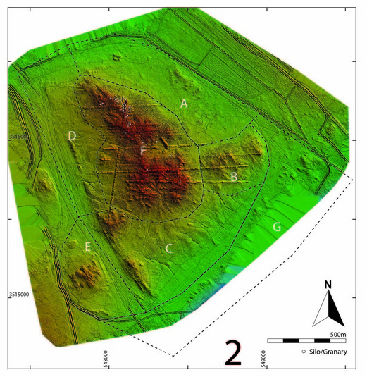
2: Fara digital elevation model with survey areas A-G, silos marked as white dots (B. Einwag, G. Luglio)
According to this early resarch, the site was settled throughout the third millennium and the town area comprised numerous residential houses and silos. Many other important questions, however, remained unanswered. Around 1000 clay tablets discovered in the houses tell of a centralised administration under the direction of an emperor and the town goddess of Sud (dSU.KUR.RU); however traces of public buildings, temples, or even a city wall had so far been missing.
The objective of our project therefore was to survey the surface of the entire town area, which not only consists of the main hill explored by Andrae through search cuts, but furthermore of an extensive lower town surrounding this main mound. During three campaigns in 2016, 2017 an 2018 we surveyed almost the entire area of the lower town. In 2018, Jörg Faßbinder and his team (Marion Scheiblecker, Sandra Ostner) additionally carried out geophysical explorations.
There had been massive illegal excavations and lootings of the main hill between 2003 and 2006. Millions of looting holes cover the entire mound, which rises up to 10 metres, destroy the upper levels and thus make a systematic survey impossible.
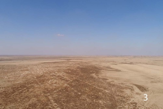
3: View over area B with the remains of the search cuts by Andrae
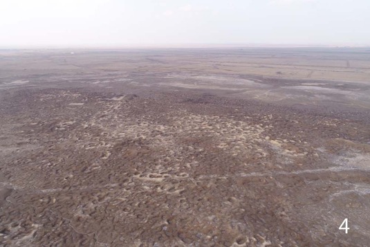
4: Looting holes cover the entire mound of Fara (drone photo: Friederike Einwag)
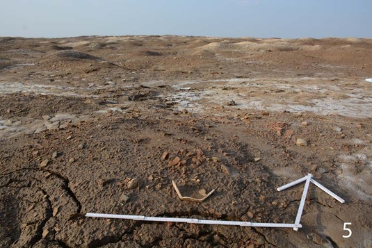
5: Excavated soil beside an old looting hole, with a half-preserved early dynastic stone bowl
Fortunately, the flat lower town had been looted only at a few spots and was in better condition. During the survey we could make out various areas of industrial use. Since the town was abandoned at the beginning of the second millennium and has never been resettled since, the levels of the third millennium are directly at the surface. Hence, the visible structures and concentrations of artefacts and waste at certain points enabled us to approximately determine areas of use within the town areas. For instance, we were able to identify places of pottery production, brick production, stone working, silos, as well areas for grinding grain and baking bread, and more.
. 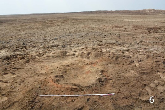
6: Oven in the lower town
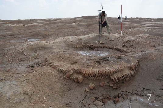
7: Silo in the upper town
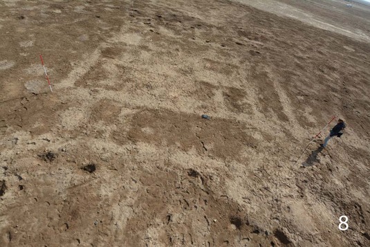
8: Ground plot of an Early Dynasitc house in area B
On aerial pictures, which we made after the winter rains in 2018, also numerous buildings and streets are visible in those areas that had not been destroyed by lootings.
The magnetometer prospection in 2018 rendered further unexpected results: at the eastern fringe of the town a part of the city wall was discovered, as well as a very large building in the centre of the main mound, which most likely represented the temple of the town goddess.
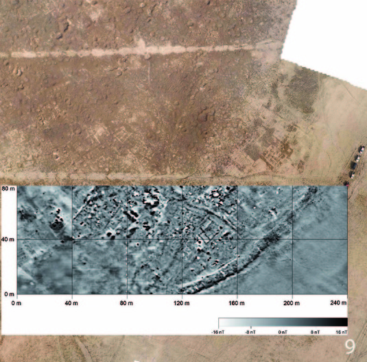
9: Combined results of magnetometer prospection and drone photography: The city wall of Fara and Early Dynastic IIIa houses at the southern edge of Mound B (J. Faßbinder/B. Einwag)
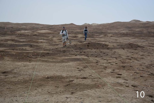
10: Prospection in Fara
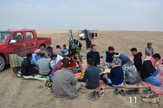
The only living beings in Fara nowadays: archaeologists (here invited for a meal by the guards) and camels.

The Team
- Archaeology: Adelheid Otto and Berthold Einwag, Christoph Fink, Hardy Maaß (2016-2018); Pierre Borsdorf, Friederike Einwag, Johannes Einwag (2018).
- Geophysics: Jörg Faßbinder, Marion Scheiblecker, Sandra Ostner (2018, all LMU)
Acknowledgements
Literature
- Adams, R. McC. 1981. Heartland of Cities. Surveys of Ancient Settlement and Land Use on the Central Floodplain of the Euphrates, Chicago.
- Andrae, W. 1903. Ausgrabungen in Fara und Abu Hatab. MDOG 17, 4−35.
- Heinrich, E. – Andrae, W. (eds.), 1931. Fara. Ergebnisse der Ausgrabungen der Deutschen Orient-Gesellschaft in Fara und Abu Hatab 1902/03. Berlin 1931.
- Martin, H. P., 1988. Fara: A Reconstruction of the Ancient Mesopotamian City of Shuruppak, Birmingham.
- Schmidt, E., 1931. Excavations at Fara, 1931. University of Pennsylvania's Museum Journal 2, 193–217.
- S. E. Hahn, J.W.E. Fassbinder, A. Otto, B. Einwag, A.A. Al-Hussainy, Revisiting Fara: Comparison of merged prospection results of diverse magnetometers with the earliest excavations in ancient ˇSuruppak from 120 years ago. Archaeological Prospection 2022, 1–13.
- Adelheid Otto & Berthold Einwag, The Fāra Regional Survey Project (FARSUP) (2016–2018), In: A. Otto und K. Kaniuth (ed.), 50 Jahre Vorderasiatische Archäologie in München. MAAO 7 (2022) 326–333.
- A. Otto, 120 Jahre nach den Pionierleistungen der DOG: Neue Forschungen in Fara/Schuruppak, einer sumerischen Stadt des 3. Jahrtausends v. Chr. In: J. Marzahn, D. Wicke (eds.) Zwischen Schwarzem Meer und Persischem Golf. 125 Jahre Deutsche Orient-Gesellschaft, Darmstadt 2023, 152-159
Publications relating to the Project
- A. Otto, B. Einwag, The Survey at Fāra – Šuruppak 2016–2018, in: A. Otto, M. Herles and K. Kaniuth (ed.), Proceedings of the 11th International Congress on the Archaeology of the Ancient Near East, Volume 2. Wiesbaden 2020, 293-306.
- A. Otto, B. Einwag, A. Al-Hussainy, J.A.H. Jawdat, C. Fink, H. Maaß, Destruction and Looting of Archaeological Sites between Fāra / Šuruppak and Išān Bahrīyāt / Isin: Damage Assessment during the Fara Regional Survey Project FARSUP, Sumer 64 (2018) 35-48.
- N. Marchetti, B. Einwag, A. Al-Hussainy, G. Luglio, G. Marchesi, A. Otto, G. Scazzosi, E. Leoni, M. Valeri, F. Zaina, QADIS. The Iraqi-Italian 2016 Survey Season in the South-Eastern Region of Qadisiyah, SUMER LXIII (2017) 63-92.
- A. Otto, Auf der Suche nach der Stadt des Sintfluthelden, 95. Jahresbericht der Münchener Universitätsgesellschaft, München 2016, 44-47.
Contact
- Prof. Dr. Adelheid Otto: aotto@lmu.de
- Dr. Berthold Einwag: einwag@lmu.de
Former Research
- Deutsche Orient-Gesellschaft in 1902-03 (http://www.orient-gesellschaft.de/forschungen/projekt.php?p=14)
- University of Pennsylvania in early 1931 (http://dla.library.upenn.edu/dla/ead/ead.html?id=EAD_upenn_museum_PUMu1020)