

KALAM
Project ‘KALAM. Analysis, protection and development of archaeological landscapes in Iraq and Uzbekistan through ICTs and community-based approaches’, funded by the Volkswagen Foundation
Since 2022, the Institute for Near Eastern Archaeology at LMU has been conducting a new international project led by Adelheid Otto with the aim of protecting endangered archaeological landscapes in Iraq and Uzbekistan, where extensive areas with thousands of cultural heritage sites are acutely threatened by looting, settlement construction, agriculture and dam construction.
The project is being carried out on the basis of equal cooperation with archaeologists in Iraq, Uzbekistan and Italy. Its aim is to systematically document archaeological sites, develop sustainable methods of protection in cooperation with the local population and raise awareness of the value of cultural heritage.
It is funded by the Volkswagen Foundation from 2022 to 2025 as part of the international initiative ‘Global Challenges - Integrating Diverse Perspectives on Heritage and Change’, which brings together the Volkswagen Foundation, the Compagnia di San Paolo in Italy and the Riksbankens Jubileumsfond in Sweden.
https://www.volkswagenstiftung.de/en/funding/funding-offer/global-issues-integrating-different-perspectives-cultural-heritage-and-change
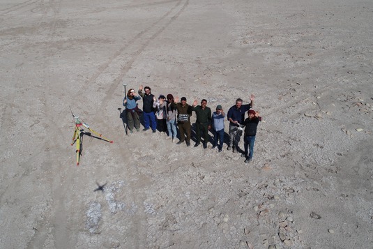
Fig. 1: The team from above
Objectives and Measures
Task 1: Analysis. Assessment of archaeological landscapes through remote sensing and archaeological survey
The LMU team has surveyed one of the areas most affected by looting in Southern Iraq, covering an area of 680 km2 in the province of Diwaniya between the two large urban centers of the 3rd and 2nd millennium BC, Fara/ancient Šuruppak and Ishān Baḥrīyat/ancient Isin.
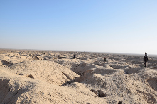
Fig. 2: The site of Isin, massively disturbed through looting holes
The systematic surface survey covered 105 archaeological sites. It was combined with remote sensing techniques and the study of old maps and documentation to gather comprehensive information on the history and development of this region over 7,000 years. At the same time, landscape features such as ancient waterways, roads, watchtowers and other features are being documented so that the ancient landscapes, which are under acute threat from agriculture, road construction, settlement expansion and other modern construction measures, are also recorded.
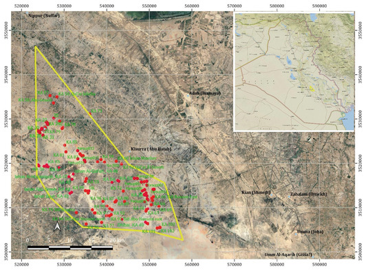
Fig. 3: The 105 recorded archaeological sites of the surveyed region in the Province of Diwaniyah
The surveyed settlements can be dated between 5000 BC (Ubaid period) and 1930 AD (late Ottoman period) based on the documented sherds, tools and other artefacts. Within this long period, there is evidence of both large cities covering up to 250 hectares and small hamlets or individual buildings covering 1 hectare or less. All structures are systematically documented with photographs and aerial images, and digital elevation models are calculated.
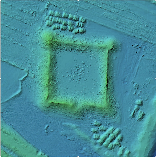
Figs. 4, 5: View and digital elevation model of an Ottoman watchtower
In combination with the study of ancient river and canal courses, the diachronic development of ancient cultural landscapes, mostly caused by the shifting of waterways at that time, can be reconstructed in detail.
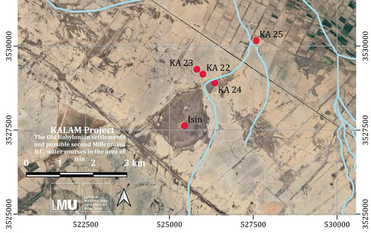
Fig. 6: Reconstruction of the channels near Isin in the Old Babylonian era
Task 2: Protection
Sustainable protection of cultural heritage can only succeed if the respective local communities are involved. The LMU team has taken several measures to this end.
The first is to train local officials, especially the many employees of the local antiquities authorities, in digital and conventional methods of data collection, processing and storage. Over the past few years, they have been trained in conducting surveys of archaeological sites and landscapes, in remote sensing using satellite images and drone photos taken on site, geoinformation systems and databases, and many other methods.
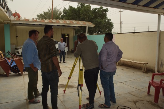
Fig. 7: Training in measuring technologies
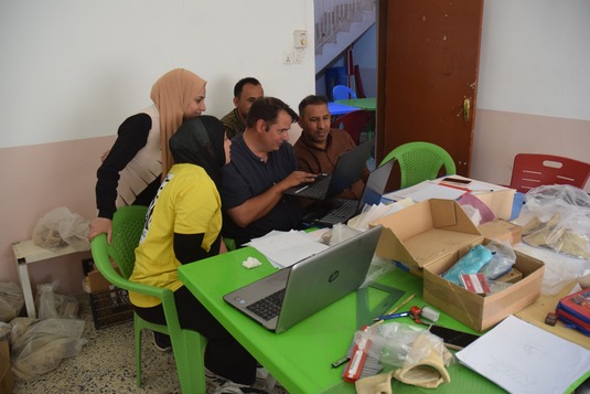
Fig. 8: Training in computer technology
This will enable them to continue systematically documenting ancient settlements, old channel systems, bridges, road networks and other features, and to map their condition and level of endangerment.
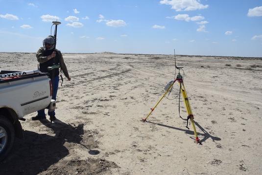
Fig. 9: Measuring on site
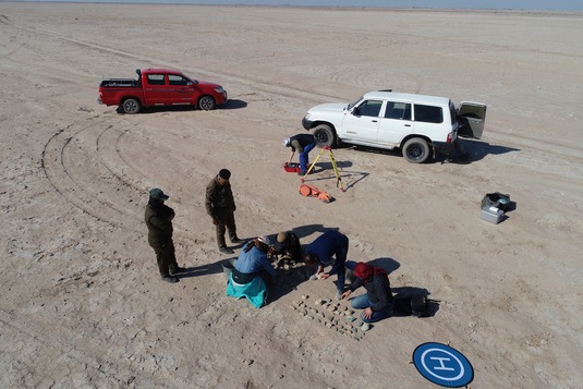
Fig. 10: Classifying collected sherds
The LMU team developed a mobile app in form of a geo-based interactive informative platform for monitoring sites in Iraq, in both Arabic and English language. Since mobile phones are the only means of communication that almost everyone in Iraq owns and uses frequently, a mobile app is a particularly effective way of involving the community in monitoring cultural heritage. The app, developed by the KALM project, allows the Iraqi and the international community to get more information about archaeological sites and to participate in the monitoring of the often endangered sites.
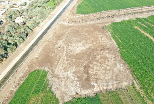
Fig. 11: A tell with a huge building is acutely threatened by farming, as shown on an aerial photograph
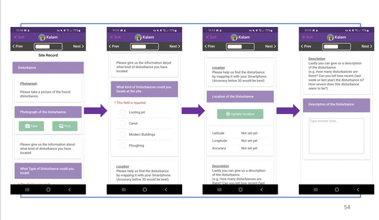
Fig. 12: Mobile app for the documentation of damages to cultural heritage sites
Task 3: Development
KALAM aims at framing and enhancing the involvement of communities in the management and preservation of their local cultural heritage
Community commitment is boosted by real and virtual visitor centers. The real visitor centers are located at various places in Iraq and Usbekistan, the virtual visitor center was developed as a particularly durable and far-reaching form of information access.
Presently, the LMU team is finalizing an exhibition in a community centre in Pashkhurt (Surkhandarya province, Uzbekistan). In close cooperation with the local authorities, the exhibition on the region‘s pre-historical and early historical development will be placed in the local school in the centre of the modern village of Pashkhurt. The Kalam exhibition will focus on the scientific investigation of the region, and our resulting knowledge of the pre-modern occupational history, conveyed through wall-mounted information panels. One part of the exhibition will be dedicated to archaeological methods and the basic principles of cultural resource protection, to enable local residents to reflect on, safeguard, and actively manage the remains of their home’s past.
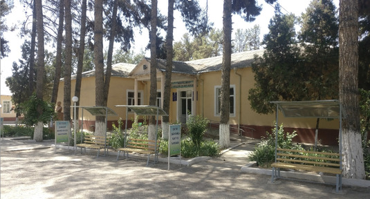
Fig. 13: Exhibition building in Pashkurt (Uzbekistan)
Very innovative and tailored precisely to the needs in Iraq‚ a “virtual visitor center” is presently developed for Southern Iraq. It includes tailored videos that can be viewed on mobile phones by a broad audience, from school level to advanced levels. It will furnish information about the rich cultural landscape and heritage of the Diwaniya province on a bilingual website where detailed travel informations for traveling in Qadisiyah region incl. coordinates of locations, maps, directions, site sheets are housted. A series of short films presenting the invaluable, but massively endangered cultural heritage will be accessible through this website, and additionally promoted via facebook and other social media channels.
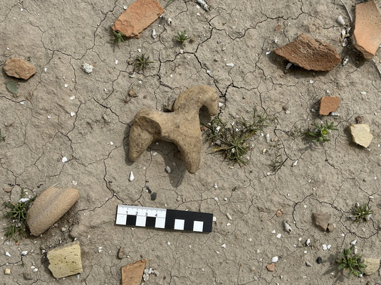
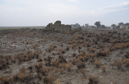
Fig. 14: Survey find after rain
Results
The results are disseminated via public talks and publications.
1. Public Talks
- C. Fink und J. Jawdat 2022. “KALAM: The Preliminary Collected Data of Survey 2022”. Within the framework of the Colloquium on the Ancient Near East, LMU München.
- J. Jawdat 2024. “The KALAM Project: The Preliminary results of the 2023-24 Survey between Šuruppag and Isin”. Within the framework of the Colloquium on the Ancient Near East, LMU München.
- A. Otto and J. Jawdat 2024. “Rescuing the archaeological landscapes in Qadisiyah Province (Irak), training and awareness raising”. In the Global Issues Convention, Hanover.
- J. Jawdat and A. Otto 2024. “From the Uruk Period to the Sassanian Period in Southern Mesopotamia: A Brief Overview of the Results of the KALAM Project”. Pulbic talk at LMU München.
- J. Jawdat. 2025. “KALAM Project: Reconstructing the Old Babylonian landscape and documenting the risk of the archaeological heritage between Šuruppak and Isin (Irak)”. 14. International Congress on the Ancient Near East (ICAANE) in Lyon (France).
- J. Jawdat. 2025 (October, forthcoming). "Some aspects on the Hydrography between Šuruppag and Isin according to the KALAM survey". Within the first conference of the SNSF Sinergia project ”Hydrography of Mesopotamia. Rivers and Channels in Babylonia from the 4th to the 1st millennium BCE”, in Bern (Switzerland).
2. Publications
- A. Otto & B. Einwag, „The Fāra Regional Survey Project“, in: A. Otto und K. Kaniuth (ed.), 50 Jahre Vorderasiatische Archäologie in München. MAAO 7 (2022) 326–333.
- B. Einwag, A. Otto & J.W.E. Fassbinder, „Harbours, Water Gates, and Canals in Šuruppak and Ur. New Results from Old Sites“, in: L. Romano (ed.), Sumer and the Sea: Delta, Shoreline, and Urban Water Management in 3rd Millennium Mesopotamia. ARATTA 3, Turnhout 2025, 91–100.
- F. Bachmann, „The Uruk period in the Qadissiyah region (Irak)“. Poster at the 14th ICAANE in Lyon (France)
- A. Otto & J. Jawdat, with contributions by Berthold Einwag and Christoph Fink: Results of the 2022–2024 Survey between Fara / Šuruppak and Ishān Baḥrīyat/Isin within the framework of the KALAM Project, summer 2025. (in print)
- J. Jawdat & F. Bachmann, “Uruk Period sites in the Heartland of cities between Fara/Shuruppak and Isin/Ishan Bahriyat”. (in preparation)
Staff
Besides the principal investigator, the team includes Dr. Berthold Einwag, Dr. Kai Kaniuth, Jacob Jawdat M.A. and Christoph Fink, M.A.
Dr. Friederike Bachmann participated in the surveys of 2023 and 2025. Ilona Spalinger is the project administrator.
Numerous colleagues and students from Iraq and Germany (LMU München) participated in the local campaigns.
Further Information
University of Bologna project website: https://site.unibo.it/kalam/en
Press Release: https://www.lmu.de/de/newsroom/news-und-events/news/lmu-startet-projekt-zum-schutz-des-kulturellen-erbes-in-irak-und-usbekistan.html
Contact
- Prof. Dr. Adelheid Otto: aotto@lmu.de
- PD Dr. Kai Kaniuth: kaniuth@vaa.fak12.uni-muenchen.de
- Jacob Jawdat, M.A.: jacob.jawdat@vaa.fak12.uni-muenchen.de