

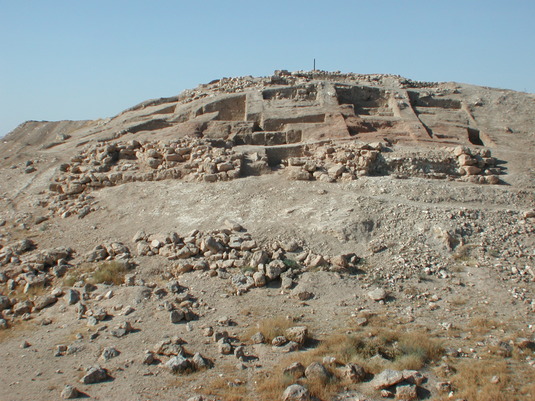
Citadel
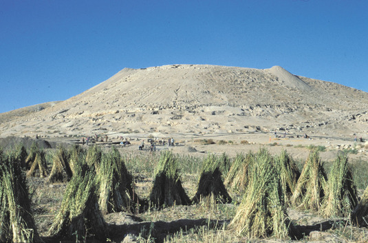
View of the Citadel with the Northern Town at its foot (2001)
Citadel
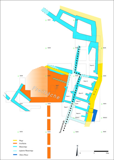
The focus of the excavations on the plateau of the citadel was on two locations at first (1993-98): the eastern corner and the north-western corner. Furthermore, a profile, running across the middle of the plateau from East to West, was cut that connected the cut on the eastern hill slope with the excavation sites on the western hillside of the plateau, which had already been explored in 1994. Within this cut a temple was laid open in 2004, which we examined until 2008. The southern hillside of the citadel - the area up to the neck-formed cut - was equally examined from 2004-2008.

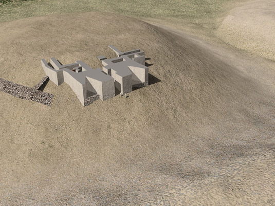
Diagrammatic plan of the Citadel
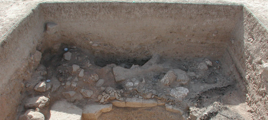
Citadel, Gate Area
The excavation area was determined where the access to the citadel was supposed to have been, since the way ascending to its plateau could be made out on the surface there. The objective was to uncover the gate complex of the uppermost Late Bronze Age enclosing wall of the plateau, which granted access to the innermost area of the citadel. It turned out, however, that the uppermost wall, which exhibited spurs (towers?) in regular intervals and used to be straight otherwise, formed a big jutting Zingel (weit vorspringenden Zingel). At the western end of the wall, four big monoliths of up to 1.35m length had tumbled down, which probably used to form the side walls of the gate. The opposite side of the passage, however, is completely eroded, so that the form of the gate cannot be determined (fig. below: level 6).
While the actual objective, the exploration of the gate, was only partially achieved, we surprisingly discovered the walls of a deeper layer just beneath this layer (fig. below: level 5). This was not to be expected at this place, since the natural rock in many places lies directly on top. This layer exhibits an access to the citadel and to several rooms.
![Abb_Luftbild_tor [Konvertiert]7_16](https://www.vorderas-archaeologie.uni-muenchen.de/forschung/projekt_syrien/bilder-tall-bazi/web_bilder_l/abb_luft_ert_7_16_l.jpg)
Excavation site Citadel Gate Area (State: 2001)
About 600 square metres of this layer 5 have been laid bare. It shows the way to the plateau, ascending to a four-metres broad staircase with at least seven steps. These stairs led to an area above a channel that granted access to three rooms (0, 1, 2) on the valley side.
Only their cellars have been preserved, but room 1 contained several collapsed levels of the upper floor with strikingly much fine ceramics (in part with a dark grey or white, streaky burnished surface), as well as an accumulation of animal bones in ashes, tops of suction pipes (saugrohrspitzen), tokens and jewellery, where it can be deduced from that certain social activities of not quite destitute people had taken place there.
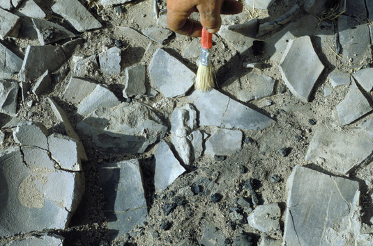
Cellar 2, which is more than 2m deep in the rock, held a surprise. Below a 1.6 m-thick filling of almost sterile soil, it revealed several complete vessels and innumerable animal bones, which were in part still naturally assembled and exhibited cutting traces. So they obviously were deposited there as pieces of meat. In between we found a lot of beads from glass, glass drip or snail-shell (Schnecke), some bronze vessels and a mysterious bitumen object. In the absence of exact comparative objects, we suppose that they were deposited pieces of meat and offerings for a kind of inauguration rite for this room complex (Einwag – Otto 2006, 113-123).
Excavation site Citadel Gate Area, view from the East (in the foreground cellar no. 2)
Left to the above-mentioned stairs, a narrow path paved with flat stone steps, shards and gravel led up to the peak of the citadel. To its right, a door with monolithic side walls led into a room of at least 10 metres length, which in its first phase used to be partially paved with slabs. Three pedestals on the ground may be best identified as pillar bases.
The final phase of this layer was obviously destroyed by fire, as many burnt beams and burnt parts of collapsed roofs prove. There is no complete inventory of the buildings, but we found numerous fragmentary figurines, two glass-drip cylinder seals of Mitanni Common-Style, jewellery, bronze and stone tools and fine ceramics. These remainders (overlooked upon looting?) give evidence of a wealthy social class living here. The preliminary age determination is the 15th century BC.
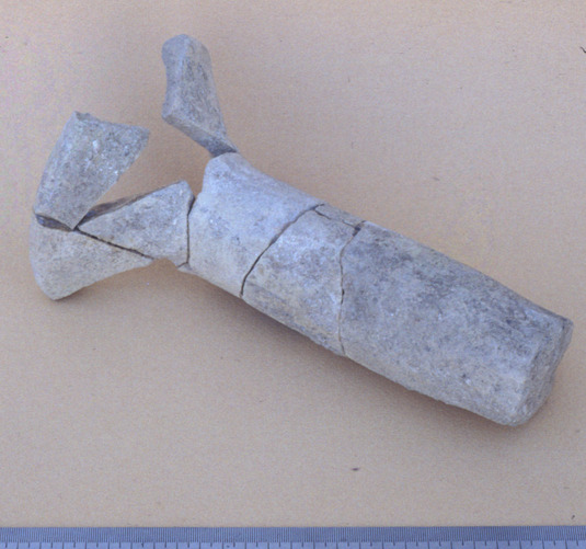
Glass-drip cylinder seal Bz 46/30:23 (L. 2.3 cm, D. 1 cm) (Einwag - Otto 2006, 120-123)
The structure of an even deeper layer, cut into at the north-eastern corner (fig. above: level 4), is still unclear, but according to the finds it can be dated to the Late Bronze Age.
In 2001, we discovered a channel south of the rooms, carved out of stone, which to some extent still featured its original slab coverage. At several points, where it disappears below the stone plates, the channel slightly changes its course. Whether there are sumps, where the water used to be cleaned and then piped further on, remains to be examined by cutting a profile at one of these points. But at least we could trace the channel for about 16 metres to a basin surrounded by a wall, which was situated further below and may have been part of a reservoir. The existence of the reservoir, which on account of the cavity we presumed to be located in the north-western corner of the citadel, thus seemed to be confirmed. However, we still have to determine its dimensions, especially its depth, its accessibility and other feeds.
During further examinations in 2008 we came to the conclusion that the reservoir and the channel carved out of stone were built in the Early Bronze Age.
Eastern Plateau
In the North-East the profile cut already back in 1993-94, which leads from the foot of the hill across the entire eastern hill, reaches the citadel plateau. In contrast to the steep hill sides, Late Bronze Age buildings on the steplike arranged terraces on the flatter area of the beginning plateau are well preserved. The finds of fictile models of intestines (models of sheep's liver and and a sheep's colon. Einwag - Otto 1996, 20-22, Tab. 14) made us expect buildings of special structure on the outer border of the uppermost terrace. This is the reason why in the year 2000 we extended the old profile to an area excavation site. In a first phase, we opened up six and a half areas of 4m x 9m surface, which after the removal of several profile walls rendered an examined area of 400 sqm. This area was enlarged to around double size in 2001 by means of extensions to the South and West and by cutting trial profiles across the plateau.
Kite photo of the excavation site Citadel Eastern Plateau with an open space and a line of rooms on the terrace below
(North is to the right)
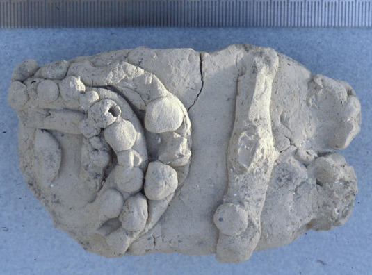
Model of the colon (L: 9,9 cm) Terracotta wall nail (L: 23,3 cm) Citadel, eastern part Citadel, western part
The result, however, was surprising in as far as there wasn't any building, but an open space of at least 150 sqm. We detected surrounding terrace walls to the North and East, but did not reach the southern and western ends of the open space. A stone setting in the middle of the place - which might be interpreted as an altar -is reminiscent of a cultic terrace in combination with a sanctuary.
A 2m-broad profile was cut from this excavation site westwards across the whole citadel plateau. The profile exhibited loose layers of wafted soil, which are typical of open spaces, and otherwise only fragmentary terracotta wall nails, which are analogue to those of Emar in front of the entrance to temple M2 (J. Margueron, in: D. Beyer (Eds.), Meskéné-Emar. Dix ans de travaux (1982) 33f, fig. 9-10). Fragments of this kind of wall nails were already found at the western end of the plateau in 1994. The northern edge of the temple was not determined until 2004.
Diagrammatic plan of the excavation site Citadel eastern Plateau (State: 2001)
On the terrace directly below the open space we discovered remainders of rooms (room 1 and the area north of it); again one terrace below there were several rooms (rooms 2-6) in a row, which had interconnection, but could only be reached via a path running parallel to the hill. The dimensions of these rooms are about 4.5 x 3x5 metres and are almost rectangular. Their walls are up to 2m high on the hill side; on the valley side only few layers of stone have been preserved. It is remarkable in this context that the complete walls are made of stone and not of mud bricks, which may be due to their second function as terrace walls. Inside the rooms, there were several installations of a kind of stepped pedestals (stairs?) or basins. The mobile inventory consisted of ceramic vessels (but in contrast to the western town houses there were no large storage vessels), various fragmentary terracotta figurines of women, parts of so-called house models, jewellery and bronze tools. Furthermore, a striking amount of deer antles were lying on the ground or were actually fitted into the wall bonds.
There is no clear answer yet neither as to the function of these rooms, nor to the question whether they were single-room constructions or part of a more comprehensive complex.
But at least we can observe four layers of several phases, which date to the Middle and Late Bronze Ages. The rooms of the individual phases partly overlay each other or directly correlate with the previous structures through their wall settings. These MBA- and LBA-buildings are set on a broad mud brick wall with a thick plaster edge, which was laid open east of the path on a small area. It dates back to the Erly Bronze Age IV. Judging from the ceramics and other finds, the uppermost layer may be dated to about the same epoch as the western town.
There is a direct correlation of the layers excavated here with those of the north-western corner of the citadel via the uppermost enclosing wall, which surrounds the entire citadel peak and connects this excavation site with that in the North-West. While the corresponding layers in the North-West are almost completely eroded, several phases have been preserved here.
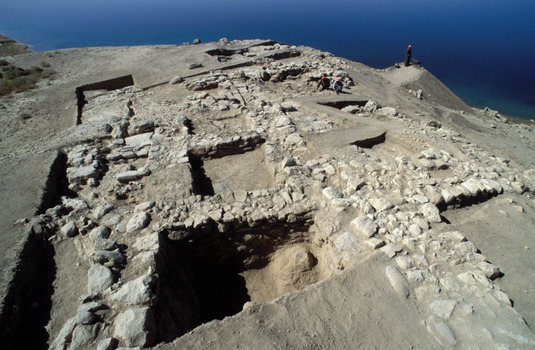
Citadel - southern hillside: the fortified gate building dating to the EBA IV (Building 2)
At its southern hillside, the citadel is separated by the fringe of the Euphrates mountain range by an artificial, 40-meter broad neck-like trench. There, heavy rain flushed clear a broad mud brick wall in spring 2004. As scraping on the surface has already shown, it forms part of one single building measuring approx. 26m in width from East to West. Its length has so far been uncovered to bout 30m. The approx. 2-meter wide mud brick walls exhibit a heavy stone plinth correlating with the neck-like trench.
Building 2, view from the South: in the foreground 3D-reconstruction of the building
the neck-like trench (by: Dr. Valentina Hinz und Dipl.-Ing. Stefan Franz G, Munich; www.hinzundfranz.de)
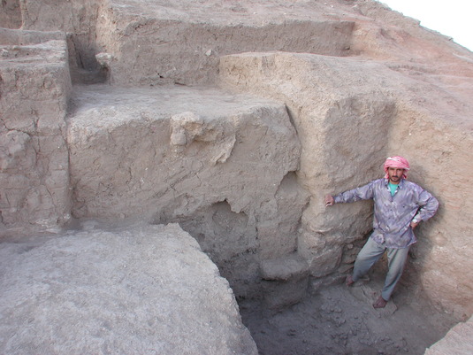
Building 2, sondage in the gate chamber with preserved walls of about 3m height
Up to 5m of the symmetrical building have been preserved in some parts and six rooms have been laid bare so far. The central entrance with two gate chambers is flanked by two projecting towers. Triangular slots are the dominat feature of the front wall at both sides of the gate. In many areas ovoid clay vessels - which may be interpreted as slung shots - were discovered, especially in the entrance area where hundreds of such objects covered the floor, mixed with some arrow heads.
Sondage in the gate area with hundreds of slung shots on the ground
According to the analysis of ceramics and small finds, building no. 2 dates back to the Early Bronze Age IV. Comparable narrow-leaved arrow heads, which were discovered in Tall Brak and numerous other find spots, are assigned to the late early Dynastic and Akkadian Period (Einwag 2008).
In all probability, Building 2 used to be a heavily fortified gate where the access to the obviously important buildings on the citadel plateau was supervised.
Sondage in the gate area of building no. 2 with hundreds of slung shots
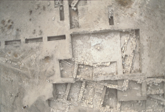
Citadel Plateau: the Temple („Building 1“)
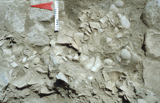
On the plateau of the citadel a rectangular room with 8m inner width was cut free in spring 2004. The 2.8 metres-wide walls from big unhewn boulders suggest a special function. Beneath the debris, ample inventory was discovered on the floor opf the final phase, a.o. a large amount of ceramic vessels, jewellery, metal tools, charred wood and cereal, as well as two clay tablets.
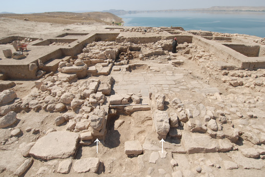
The temple (building no. 1) the entrance of which is flanked by two fragmentarily preserved lion orthhostates (= arrows),
plan view from the East
Debris and inventory on the floor of the temple
The documents each bear a dynastic seal impression of the Mittanian King Sauštatar, which was used here by himself and by his successor Artatama. They deal with the royal transfer of a locality (Sallaberger – Einwag – Otto 2006).
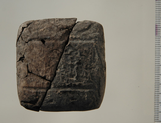
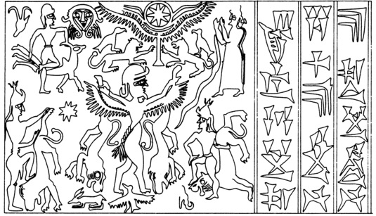
Clay tablet 1, Bz 51/23:21, deed of donation Redrawing of the Sauštatar seal
by Sauštatar with an impression of his seal (D. Stein, ZA 79 [1989] 36, Abb. 1)
As subsequent excavations have revealed, building no. 1 is a temple. In its first phase it measured about 38m in length and 16m in width and has been preserved to 3m in height in some parts.
Construction history of the temple
In the course of its 300 years of existence, the temple was rebuilt several times. Its construction history has been discussed recently (Einwag – Otto 2012).
In phase 1 an anta temple was erected on the relicts of a large Early Bronze Age building. Its walls were razed in part and the boulders and some parts of the building were reused. For instance, the stone-slab floor was reused. A broad door with a stepped soffit lead from the entrance hall into the main room. Probably two lion orthostates flanked the door, for upon our excavation large stone monoliths at the entrance obviously served as a stock sub-location for heavy, longish objects and the fragmentary stone lions had been visibly relocated to a side entrance.
In phase 2 the foreroom was separated by a wall and the axial entrance relocated to the eastern side. In phase 3 the large main room B was used as a waste area for cult inventory. Only the smaller room A, where the two lion orthostates has been relocated to, was actively used as a sacral room. Diverse fixtures usch as an altar, benches and pedestals allowed for ritual and social events in the temple room. This phase ended violently, as huge amounts of debris with remains of the inventory proove.
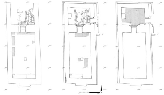
Plan of the temple showing its three phases (Einwag-Otto 2012)
Inventory of the temple
The inner room of the temple was examined from 2004 to 2008. The large room B no longer exhibited any primary inventory. Numerous layers of debris interfering with each other, however, suggest that old cultic inventory was disposed of there, for the debris included the remains of libation vessels and animal bones.
The small room A contained important rests of the former inventory. All the material was heavily burnt. In some parts traces of looting could be detected, furthermore the inventory obviously had been deliberately smashed by people. Otherwise, the tiny parts into which even thick-walled vessels were shattered, and the wide scattering of the shards of even these vessels cannot be explained.
A large amount of vessels, especially beakers and animal bones, were found concentrated in front of the central altar. They represent the remains of the inventory or of meals and offerings. Also a figurally decorated terracotta basin stood near the altar. Hundreds of vessels, amongst which also miniature vessels, were lying in the temple room.
Inventory of the temple in situ