

Historical Geography of Northern Mesopotamia in the 2nd Millennium BC
Historical Geography of Northern Mesopotamia in the second Millennium BC -
HIGEOMES / TEXTELSEM
TEXTELSEM Project:
"Texte, Tells und Semantik: Modellierung der historischen Geographie Nordmesopotamiens im 2. Jt. v. Chr. mittels der integrierten Analyse von Texten, Archäologie und Raum, Geoinformatik und dem semantischen Netz"
"Textes, tells et sémantique : modéliser la géographie historique de la Mésopotamie du nord du 2e
mill. av. J.-C. grâce à l'analyse intégrée des textes, des données archéologiques et au recours à la
sémantique du web et à la géoinformatique"
("Texts, Tells and Semantics: modelling the historical geography of Northern Mesopotamia in the second millennium B.C. by means of an intetgrated analysis of texts, archaeology and space, geoinformatics and the semantic network")
In April 2013 work was taken up on the German-French project TEXTELSEM, which is co-financed by the Deutsche Forschungsgemeinschaft (DFG) and its French counterpart, the Agence National de la Recherche (ANR). It runs over 36 months and is essentially based on the research results of the preceding project HIGEOMES, which was also co-financed by the DFG and the ANR. Participants comprise researchers of Near Eastern Archaeology (directed by Prof. Dr. A. Otto, LMU München) and Assyriology (directed by Prof. Dr. E. Cancik-Kirschbaum, FU Berlin and Dr. N. Ziegler, CNRS Paris). Works in the fields of geoinformatics and semantic data processing and presentation are directed by Prof. Dr. K.-Ch. Bruhn (FH Mainz) and Dr. C. Cruz (Université de Bourgogne, Dijon).
Project Description
The objective of TEXTELSEM is the modelling of the historical geography of the Northern Mesopotamian area in the second millennium B.C. and the creation of a virtual research environment on the basis of archaeological, philological and geographical information, which are processed with the help of IT-based forms of knowledge management.
Cuneiform texts contain a lot of toponyms and information on places, landscapes and travel routes, only part of which we have been able to associate with the real geographical situation and find spots up to present. On the other hand, 150 years of archaeological research in the Near East have been providing us with a wealth of information on settlements and spaces dating back to the corresponding periods of the Middle and Late Bronze Age. Landscape data on geography and environment complement our information pool. TEXTELSEM now aims to connect these pieces of information by extending the information integration methods that are based on the concept of semantic data description. The focus of the project is on both the acquisition and evaluation of Ancient Near Eastern texts and archaeological finds and the joint development of suitable ontologies for the description of the disciplinary databases. The information collected will finally be published both online in a web database with a linked GIS, and in the form of a book.
For methodological reasons the geographical area of the Near East has been artificially divided into zones of research (picture 1).
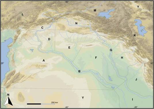
picture 1 - zones of research of TEXTELSEM
They admit of a presorting and rough association of ancient toponyms with geographical greater areas. The boarders of these zones do not represent any historical reality, but link our understanding of geopolitical structures with landscape zones. At the same time, they facilitate automatical filtering in the data bases. The areas B to F show the core area of our examinations, which had already been part of our research in the preceding project HIGEOMES. Within TEXTELSEM we have extended this region by the Eastern Tigris area (area H), which used to be an important settlement and traffic link of the Ancient Near East.
The systematic acquisition and evaluation of archaeological and space-related data is the main objective of the archaeological work at the LMU München (Adelheid Otto, Christoph Fink, Michael Herles). To this purpose, secondary literature is examined for find spots matching in time and space and entered into the data base. The focus area of TEXTELSEM research comprises an area of roughly 200.000 km². In Syria, about two thirds of the area have been examined through excavations and especially surveys, so that we have a fairly complete picture of Ancient settlement structures and its continuities. Meanwhile, more than 1100 find spots have been surveyed.
Since the environment has meanwhile considerably changed due to modern farming and hydraulic engineering, and the political situation has rendered local research impossible, we especially revert to historical maps and travel descriptions for the reconstruction of premodern farming. Digitally accessible satellite images complement our work on the description of landscape characteristics (picture 2/3).
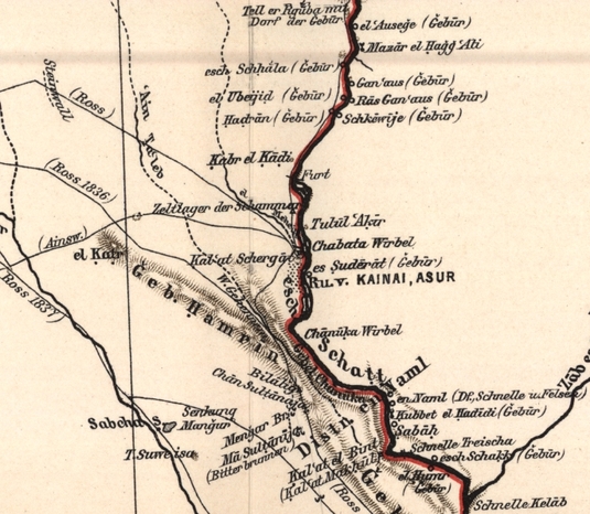
picture 2 - Detail of a historical map. Region around Assur (Oppenheim 1899)
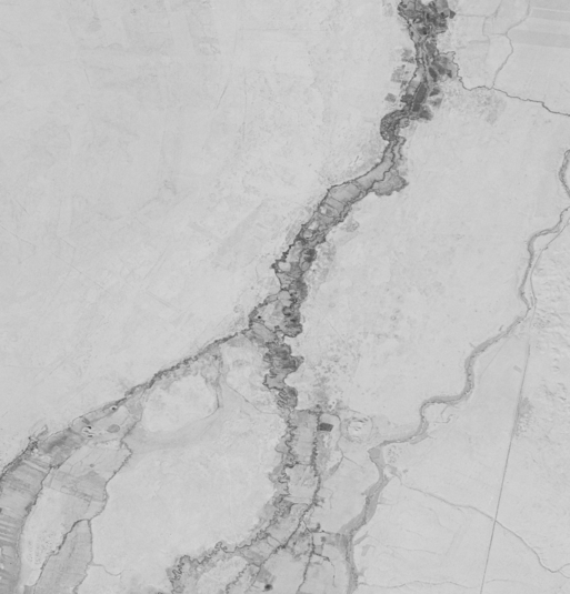
picture 3 - Detail of a CORONA photo on the region of Middle Balih
All these data are finally fused in IT-based forms of knowledge management. The basis for this is a jointly developed, knowledge-based information system that integrates subject-specific databases in a way that allows not only research and the interoperable provision of information, but also the semi-automatic generation of hypotheses. The technologies of Knowledge Discovery thus enable us to decisively narrow vague localisation hypotheses of the type "somewhere in the region XY" and to generate identification hypotheses on the basis of the knowledge available (picture 4).
The cooperation of the French and German project partners unites complementary competencies, which facilitates the combination of historical-systematical basic research and the development of new analysis and visualisation methods and its digital publication and long-term protection.
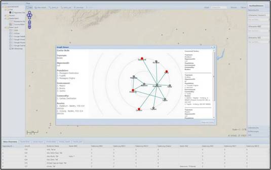
picture 4 - Graphic Visualisation in WebGIS
Publications
E. Cancik-Kirschbaum & N. Ziegler (Hrsg.), Entre les fleuves – 1. Untersuchungen zur historischen Geographie Obermesopotamiens im 2. Jahrtausend v. Chr., BBVO 20, Gladbeck, 2009.
N. Ziegler & E. Cancik-Kirschbaum (Hrsg.), Entre les fleuves – II. D’Aššur à Mari et au-delà, BBVO 24, Gladbeck, 2014.
A series of short contributions by various project participants were initiated in 2015 under the title of „En marge d’HIGEOMES“ and will be published in N.A.B.U.
Publications in preparation
A. Otto - E. Cancik-Kirschbaum - N. Ziegler (éd.), Materialien zur Toponymie und Topographie/Matériaux pour l’étude de la Toponymie et de la Topographie, erscheint in: Institut des civilisations, Proche-Orient ancien, OpenEdition Book du Collège de France, 2015.
A. Otto – E. Cancik-Kirschbaum – N. Ziegler, HIGEOMES 1 – Les itinéraries, will be published in the series of BBVO.
Links
http://www.higeomes.org/index.php/de/
FU Berlin
http://www.geschkult.fu-berlin.de/e/altorient/forschungsprojekte/Aktive-Projekte/TEXTELSEM/
CNRS Paris
http://www.digitorient.com/?page_id=2348
FH Mainz
http://i3mainz.hs-mainz.de/de/projekte/textelsem
Université de Bourgogne
http://checksem.u-bourgogne.fr/www/TexTelSem.html
http://higeomes.checksem.fr/doc/PresentationTTS.html
Contact
Christoph Fink M.A.: Christoph.Fink@vaa.fak12.uni-muenchen.de
Dr. Michael Herles M.A.: michael.herles@vaa.fak12.uni-muenchen.de
Prof. Dr. Adelheid Otto: aotto@lmu.de