

Sirkeli/Turkey
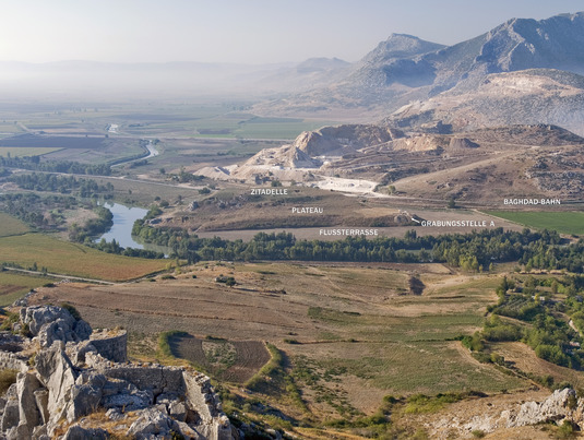
Sirkeli Höyük is situated about 40km east of the Southern-Turkish megacity of Adana in the midst of Çukurova, the Cilician Plain, at a place where the river Ceyhan channels through the Misis Mountains (Nur Dağ). This is the most important passage through Cilicia, leading eastwards via the Amanus pass to Syria and westwards via Adan and Tarsus to the Cilician Gates.
The strategic importance of this historical route becomes obvious through the Medieval castle Yılan Kalesı on the other side of the river and the trail of the "Bagdad Train" and the modern motorway, which both run directly at the Southern periphery of Sirkeli Höyük.
Both the Misis Mountains and the river, which flows round the hill at two sides, constitute a natural protection of the hill. At the same time, from Sirkeli Höyük you can overlook the entire plain east, west and north of the river bend.
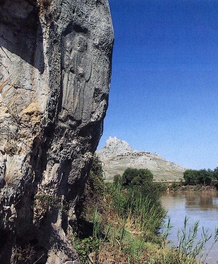
The settlement, which according to the results of surveys and excavations used to be one of the largest Bronze and Iron Age find spots of Çukurova, owed its economic and strategic key position to its geographical location. This was expressed not least in the installation of two Hittite rock reliefs below its ruins:
- The better preserved one depicts the Hittite Grand King Muwatalli II. (1290–1272 B.C.) and thus constitutes one of the oldest known Hittite rock reliefs so far.
- Nearby another, ancient chiseled, relief was found, which probably dates back to the son of Muwatalli II. - Muršili III. (1272–1265 B.C.), who was disempowered by Hattušili III. (1265–1240 B.C.).
The excavations conducted sof far evidence that the settlement was permanently inhabited from the chalcolithic period throughout the Bronze and Iron Age well into the Hellenistic epoch. There are also indications that this settlement is identical with the ancient trade and cultic town of Lawazantiya / Lusanda, the home town of the Hittite queen Puduhepa.
The first archaeological excavations on Sirkeli Höyük were carried through in 1936 in the form of a short examination by J. Garstang, as well as from 1992-1996 by the Ludwig-Maximilians-Universität München and the Bavarian Acadamy of Sciences under the supervision of B. Hrouda and in 1997 by the University of Innsbruck under the supervision of H. Ehringhaus.
From 2006 to 2011 excavations were realised by the Eberhard Karls Universität Tübingen, and since then they have been conducted by the Univeristy of Bern in cooperation with Onsekiz Mart Üniversitesi Çanakkale and the Ludwig-Maximilians-Universität München. They have brought to light a.o. a Late Bronze Age building exhibiting walls on stone plinths and ground floors made from flagstones. These finds prove the contacts of the town to Syria, Mesopotamia and Central Anatolia. The point of culmination for the supraregional trade might have been a river port, which becomes apparent in the overall appearance of the landscape and with the help of geomagnetics in the area of the Northern Lower Town.